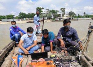
হাইড্রোগ্রাফিক জরিপ

হাইড্রোগ্রাফিক জরিপ কী? বিজ্ঞানের শাখা যা নদী, খাল, বিল, সমুদ্র, মহাসাগর ইত্যাদির মতো নিমজ্জিত অঞ্চলের টপোগ্রাফি নিয়ে কাজ করে, নিমজ্জিত অঞ্চল, পানির পরিমাণ এবং স্তর, প্রবাহের পরিমাণ, শব্দের বিন্দুর অবস্থান এবং নেভিগেশন তালিকাগুলি প্রস্তুতকরণ । একে হাইড্রোগ্রাফিক জরিপ বলা হয়। এটি ডক, আশ্রয়কেন্দ্র এবং সমুদ্র উপকূলে, জলবিদ্যুৎ, জল সরবরাহে জরিপের কাজের জন্য ব্যবহৃত হয়। হাইড্রোগ্রাফিক […]
Hydrographic Survey Steps & Service

What is the Digital Hydrographic Survey? Moreover, The branch of science that deals with the Geography of Submersed areas such as rivers, canals, beels, seas, oceans, etc. Similarly, Submerged areas, amount and level of water, amount of flow, location of Soundings points, and preparation of Seafaring lists. But also, They call this a Digital Hydrographic […]
