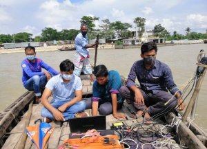
Hydrographic Survey
What is the Hydrographic Survey?
Additionally, Hydrographic survey is dealing with the topography of Immersed areas such as rivers, canals, beels, seas, oceans, etc. Moreover, to Compute the area, amount and level of water, amount of flow, location of Measurement points, and preparation of Steerage lists. Similarly, Hydrographic survey is the Preliminary work for docks, harbors, and Coastlines, Hydroenergy, water supply.

Objectives of the Hydrographic Survey
01. Similarly, Determine the position of the coastline. Therefore to notice the direction change.
02. Notice the origin and change of the beach.
03. Determining the extent of soil erosion, siltation, and marking its area.
04. Sounding to determine the characteristics of the bottom of a submerged area.
05. Calculate the hydrographic survey depth of water for navigation most importantly the amount of soil to be cut for navigability.
06. Determine the direction of water flow, speed characteristics.
07. Determination of the drainage capacity of the river.
08. Determining the average sea level and controlling the tidal time.
09. Specifically, To decide the location of the buoy, lighthouse, shelf and mountain range in the middle of the sea to clarify the safety of navigation.
10. Settling the highest and lowest levels of water surface.
11. Establish the area of contour and cross-section of the submerged area.
12. Finding the holding capacity of the closed reservoir.
Importance of Hydrographic Survey
Likewise, The importance of a hydrographic survey in Bangladesh is immense. Likewise, The reasons are as follows:
01. Bangladesh is an island-like and riverine country. Thus Numerous rivers, canals, and canals flow over it like a net and fall into the Bay of Bengal.
02. Due to its geographical location, most of the rainwater of this sub-continent flows over Bangladesh. Specifically, That is to say, most of its area is flooded every year and stays underwater for a long time.
03. Under the soil of this country, there are valuable natural resources like coal, limestone, natural gas, oil, etc. Moreover, Certainly we need to locate those resources.
04. Furthermore, We cannot implement Co-engineering projects such as roads, railways, bridges, culverts, flood control, etc. But also without knowing the nature of the subterranean terrain. Indeed conclusion we need a hydrographical explanation for those works.
05. However, The importance of hydrographic surveys for the development and maintenance of postal, seaport, or river port activities in this country are immense.

Methodology of Hydrographical Surveys in the River
Additionally, We use Echo-sounder instruments for conducting the Hydrographic Survey in the river. Moreover, We place the Echo-Sounder on an ordinary motorized boat along with a GPS ranging pole and Transducer. In fact The GPS ranging pole and Transducer should connect with the Echo-sounder SDE-28. Likewise, The GPS Base had been fixed at the shore. Sprcifically,
GPS gave the position i.e. latitude & longitude and Echo-sounder reflected the depth. Similarly, All data had been automatically plotted in the machine with the help of Navigation / Hydrographic software.
Moreover, GPS connected our known pillars which had already kept on both the banks. But also, The final output comes from our computer & plotter. The boat moved along the path as the river goes along.
Offline Hydrographical Survey
Moreover, Hydrographic survey is the science of measurement that can affect maritime navigation, marine construction, dredging, offshore oil exploration/offshore oil drilling, and related activities. Furthermore So certainly, it’s highly important to conduct a proper hydrographic survey.
Additionally Our company offers quality Hydrographic Survey Services, which meets the various requirements of our clients. In fact this type of survey, we study the physical properties, distribution, circulation, and quantities of the water bodies. Similarly The latest instruments and sophisticated techniques we apply to deliver the services.
